Big Sur: The Iconic Coastal California Scenic Drive
This realistic Big Sur California Scenic Drive Guide helps you plan your next adventure along this coastal byway.
Big Sur is a picturesque part of Coastal California, or the Golden Coast. This area appeared in countless movies thanks to its magnificent scenery.
- Sights & Places of Interest
- 1. Point Lobos State Natural Reserve
- 2. Garrapata State Park
- 3. Kasler Point
- 4. Rocky Creek Bridge
- 5. Bixby Creek Bridge
- 6. Castle Rock
- 7. Little Sur River Beach
- 8. Point Sur State Historic Park
- 9. Andrew Molera State Park
- 10. Pfeiffer Big Sur State Park
- 11. Seal Beach Overlook
- 12. Julia Pfeiffer Burns State Park
- 13. Big Creek Bridge
- Getting to Big Sur
- Where to Stay Near Big Sur
- Entrance Requirements & Passes
- Takeaways: Big Sur California Scenic Drive
This post includes affiliate links that will earn us commission if you make a purchase via these links.
Sights & Places of Interest
Big Sur takes a special place among all Coastal California destinations. The rugged coast of Big Sur is home to the most famous scenic drive in California.
There is a lot to see in Big Sur. It is only a few hundred miles north of Channel Islands National Park. But Big Sur give you a very different experience of Coastal California.
It is easy to spend a full day along this fairly short section of Highway 1. There are a handful of state parks, viewpoints, and trails.
But Highway 1 is also a point of interest in itself. You have certainly heard about this scenic drive. California State Route 1, CA-1, Highway 1, or Cabrillo Highway are different names of this road.
The last name refers to Juan Rodriguez Cabrillo, a European explorer of California. Cabrillo National Monument in San Diego also carries the name of this explorer.
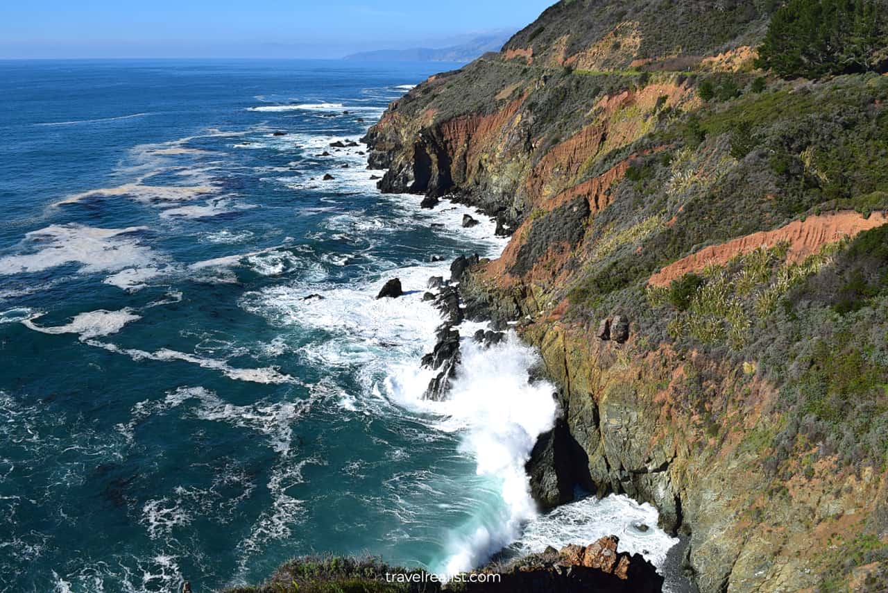
Highway 1 proceeds along the Pacific Coast of California. It constantly gains and loses elevation. The ocean shore, winding turns, and bridges make Highway 1 one of the most scenic drives in the U.S.
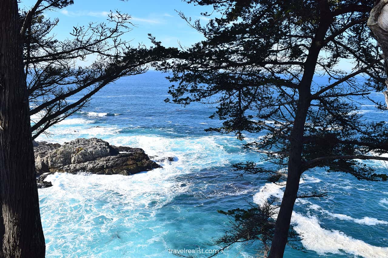
1. Point Lobos State Natural Reserve
Point Lobos could be your first park if you enter the Big Sur Area from the north. It is about 7 miles (11 km) south of Monterey.
This State Natural Reserve is an amazing starting place of your Big Sur exploration. It has great views of the Pacific Ocean, cliffs, and beaches.
Hikers, photographers, and scuba divers would find this park a worthwhile destination. Enjoy the Sea Lion Point, Cypress Cove, and Blue Fish Cove.
2. Garrapata State Park
Garrapata is the next park on the way from Point Lobos. It is a hiker’s park. There are a few coastal trails at the Soberanes Point. These trails give you an easy way to see the wildflowers and rugged coastline.
There are also more challenging Soberanes Canyon and Rocky Ridge trails. The latter trail involves 1,785 ft (544 m) of elevation gain if you plan on reaching the Peak.
You could easily spend hours in Garrapata State Park. While its trails are fantastic, you need to know what awaits you ahead in Big Sur.
The viewpoints along the way and shorter hiking trails would work better during the first visit to the region. You might decide to explore Garrapata State Park further on your second trip to Big Sur.
3. Kasler Point
You should stop at the Kasler Point if you prefer viewpoints to hikes. This spot has a clear view of the Pacific Ocean. Yet you are unlikely to see wildflowers from this viewpoint.
But you can see a small bay below the highway. It is easy to spend a few minutes watching the cliffs break the ocean waves. Do not forget, you can see it all right from the parking lot.
4. Rocky Creek Bridge
Highway 1 has a handful of impressive bridges. This structures over mountain creeks are certain to grab your attention.
There are two bridges you would not want to miss. The Rocky Creek Bridge is the first one of the two. You can park at a small pullout on the oceanside of Highway 1.
You could take a short path from the pullout to a viewpoint just below the bridge. Be extra careful as you hike down. The path is short but it is best to take your time.
This unofficial path is quite steep. It also brings you right to the cliff edge. There are no railings to save you if something goes wrong.
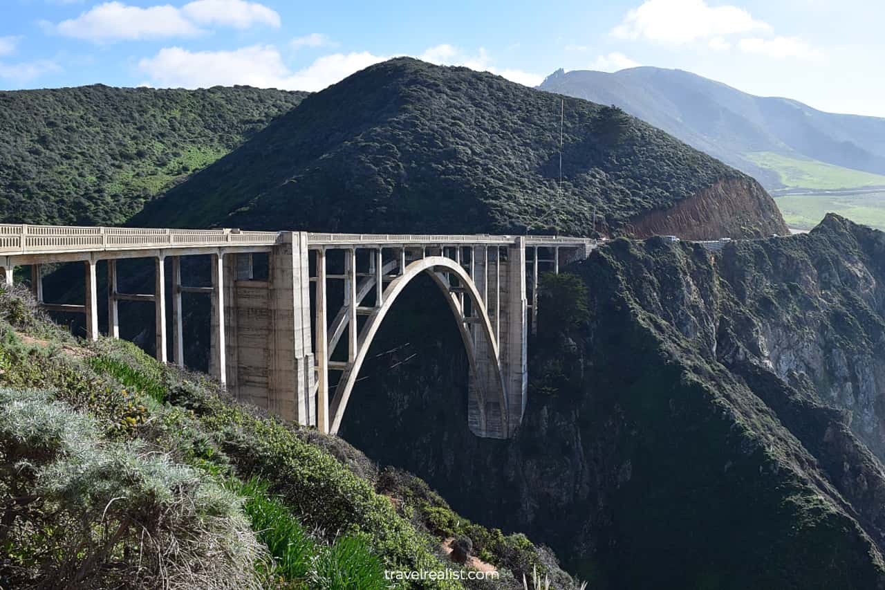
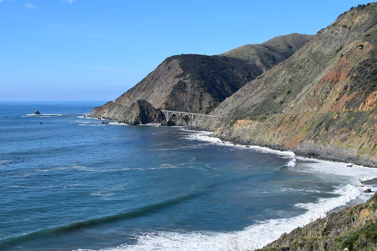
5. Bixby Creek Bridge
The Bixby Creek Bridge is the second bridge, less than a mile (1.6 km) from the Rocky Creek Bridge. This bridge is one of the most memorable on entire Highway 1.
Built and opened in 1932, this bridge continues to awe the travelers. The bridge spans 360 ft (109 m) over a 260-ft (79-m) deep canyon.
You could easily see why this bridge is one of the most photographed places on the entire highway. But the same words of caution apply to Bixby Creek Bridge viewpoint.
Do not push your luck trying to get a perfect shot of this bridge. The steep and rocky path can be quite dangerous.
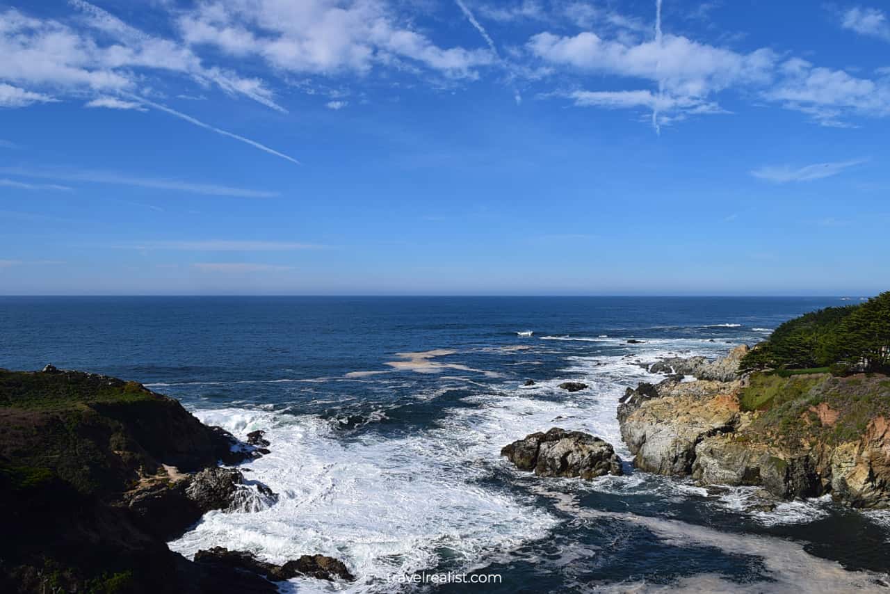
6. Castle Rock
There is still plenty to see at this viewpoint even if you do not take a downhill path. Enjoy the breathtaking views of the Castle Rock and cliffs.
This cove looks a bit like Potato Harbor in Channel Islands. It also resembles some of the cliff walks in Ireland, like Howth and Killiney.
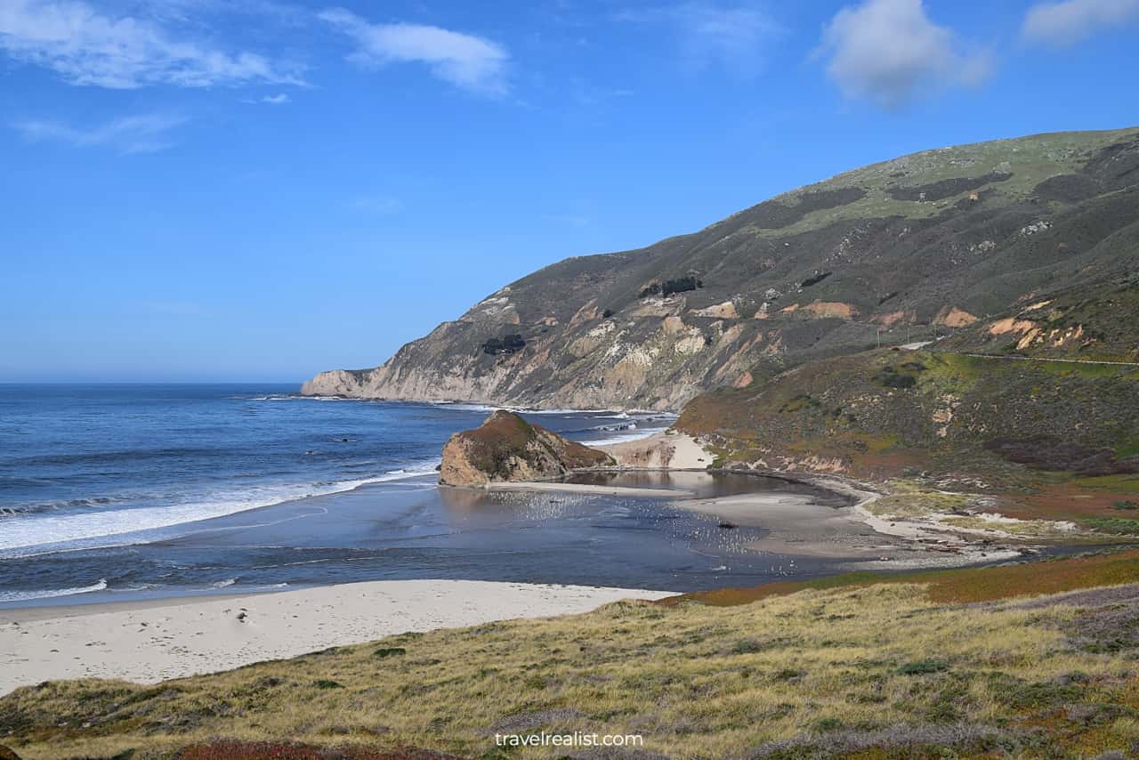
7. Little Sur River Beach
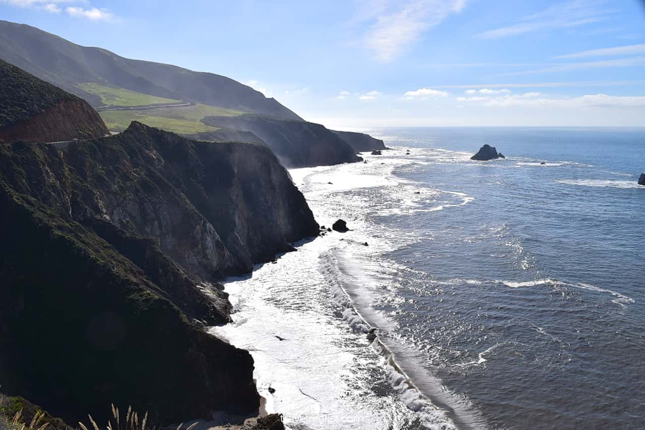
Highway 1 then proceeds via Hurricane Point, Sea Otter Refuge Viewpoint, and Great Sur Vista. All of these viewpoints are nice quick stops. You might not need much time to capture the surrounding beauty.
The highway starts to lose elevation after the Great Sur Vista. You will almost reach the ocean level near the Little Sur River Beach. The viewpoint at the river mouth brings you right next to the Pacific Ocean.
8. Point Sur State Historic Park
Point Sur is the next park along Highway 1. This park protects a historic lighthouse on a cliff. You can only visit it on a guided tour.
As a result, this area will likely be closed during your Big Sur California Scenic Drive. You can still admire the lighthouse from a distant viewpoint.
9. Andrew Molera State Park
You will enter the next state park as soon as you pass Point Sur. Andrew Molera is a great hiking destination in Big Sur.
You can explore this park at your own pace. The park has a few long hiking trails. You could choose from the Creamery Meadows, Ridge, and Bluffs trails.
You need to hike all the way to Molera Point and Bluffs to get the best views. As a result, these trails work best if you have a few hours to spare in this park. Keep driving to the next viewpoint if time is an issue.
10. Pfeiffer Big Sur State Park
Highway 1 starts to gain elevation right after Andrew Molera State Park. The scenery changes, too. The highway brings you inland through redwood groves, away from high cliffs, creek meadows, and beaches.
Pfeiffer Big Sur protects forests along the Big Sur river. It is one of the most popular parks in the region. Pfeiffer Falls, Buzzards Roost, Valley View, and Big Sur River Gorge are the main highlights of the park.
The highway briefly drops elevation after the Pfeiffer Canyon Bridge. It then ascends and curls between the cliffs at Grimes Canyon.
11. Seal Beach Overlook
Every new road turn on Highway 1 through Big Sur brings a new viewpoint. Some, like the Seal Beach Overlook, have breathtaking views of the cliffs. Others only revealed a glimpse of the ocean.
You might feel like you have seen it all after so many parks and viewpoints. Do not give in to this feeling. This is a recipe for skipping some of the best sights. You will regret this decision later.
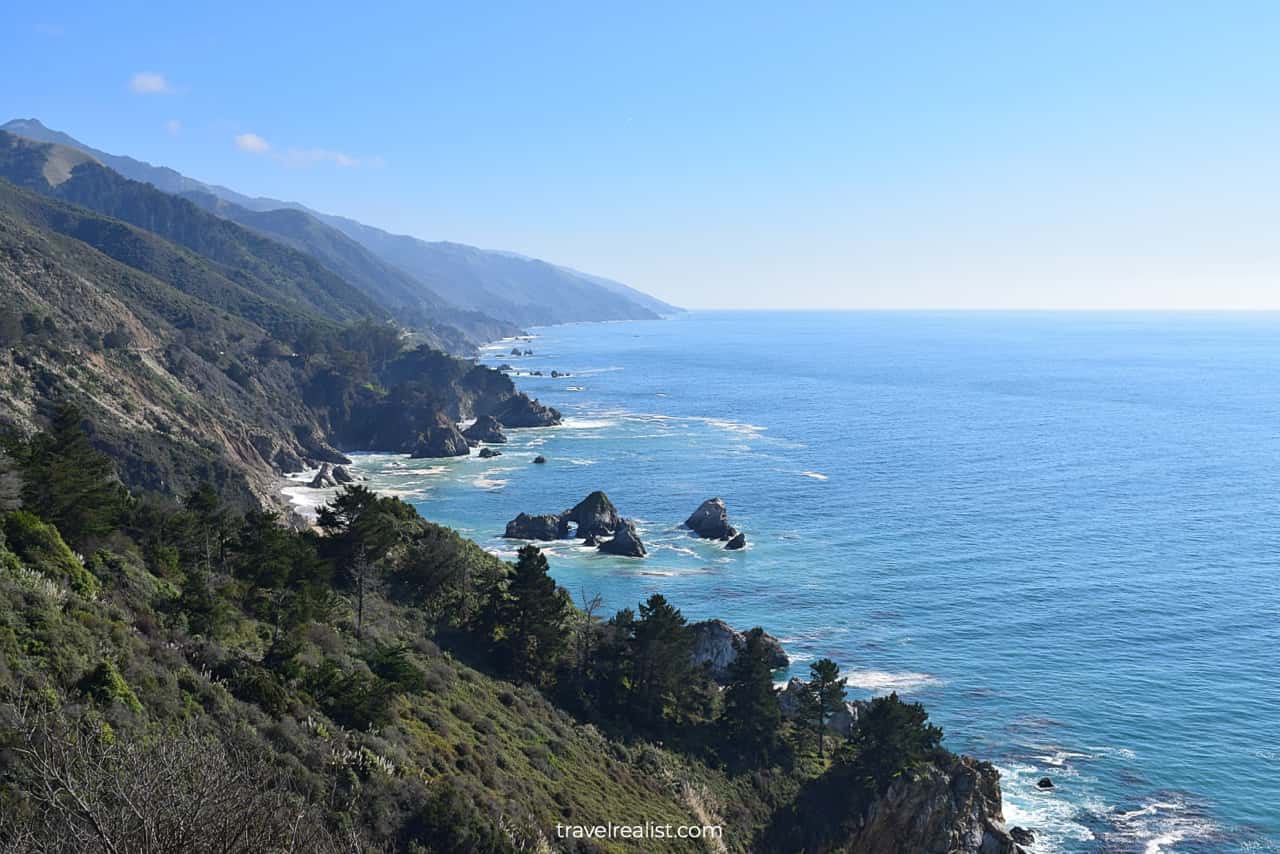
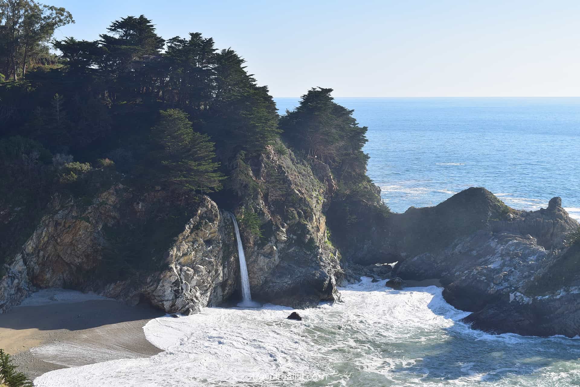
12. Julia Pfeiffer Burns State Park
Julia Pfeiffer Burns State Park is just a few minutes from the Seal Beach overlook. This state park is the highlight of any Big Sur California Scenic Drive.
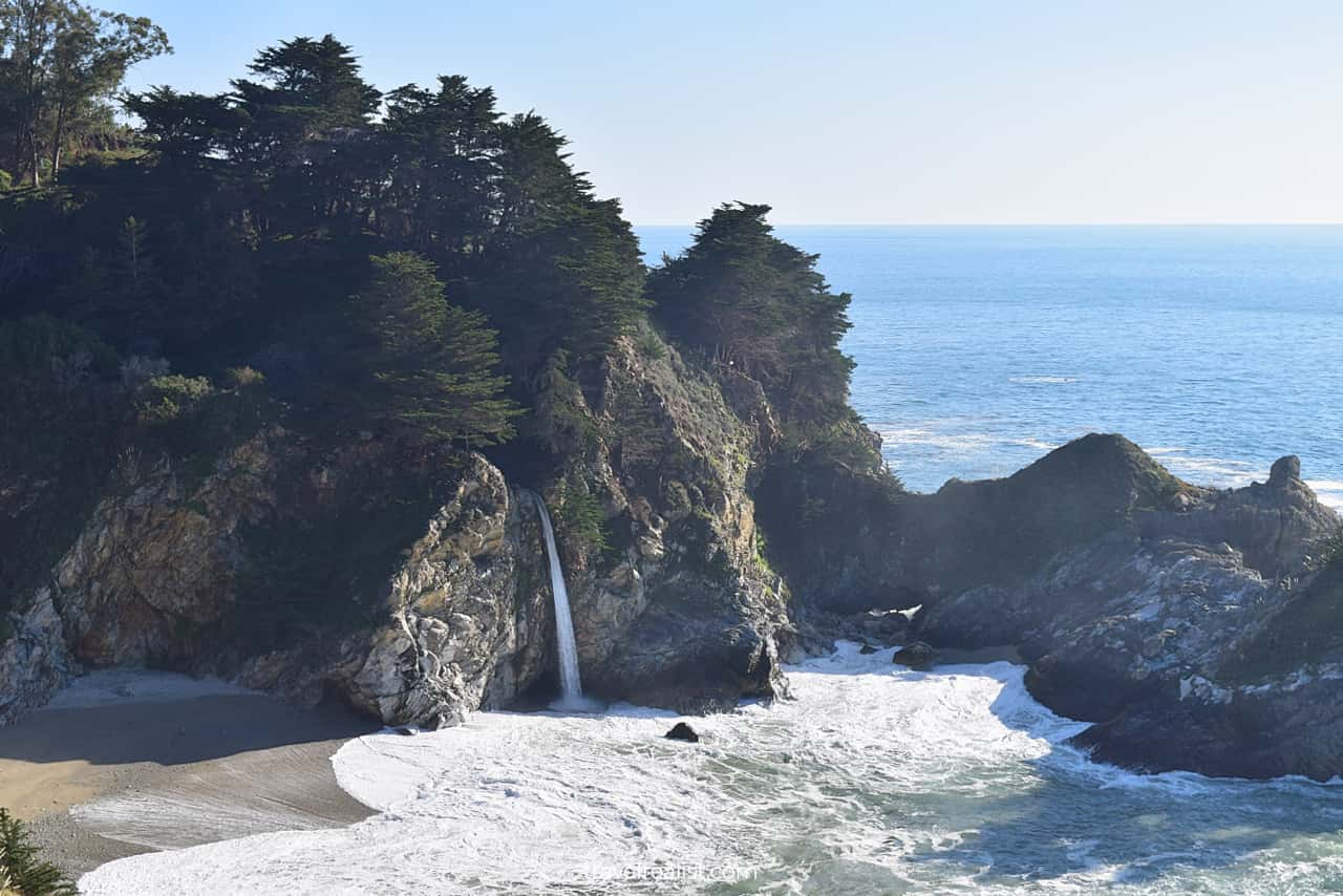
This park protects a few scenic sights: Partington Cove, McWay Cove, and McWay Falls. The park carries a name of a Big Sur pioneer woman.
McWay Falls is a true symbol of the Big Sur region. McWay Creek drops from the 80-ft (25-m) cliffs into a secluded cove.
The waterfall, cliffs, beach, and ocean make a surreal combination. You would need to take a 0.8-mi (1.3-km) out-and-back trail from the parking lot to see the falls.
The path is in a good condition. While the falls are the main attraction of the hike, there are also other things to see. Continue to the Waterfall Stone House ruins at the end of the trail.
13. Big Creek Bridge
The Big Creek Bridge is another picturesque bridge on Highway 1. The Big Creek Cove Vista Point has excellent views of the creek, cliffs, and the bridge.
This viewpoint is often the last stop on the Northern section of Big Sur. This happens if you run into a road closure on Cabrillo Highway around Lucia.
If this happens to you, you would need to turn back and drive back past the same sights. This could be a disappointing end to a Big Sur road trip. Plan your route in advance to avoid these surprises.
Continue with this Big Sur California Scenic Drive Guide. You will learn more about ways to get to the sights, entrance requirements, and places to stay.
Getting to Big Sur
Big Sur is a coastal area of Central California. Big Sur parks stretch along Highway CA-1 and Pacific Ocean between the towns of Monterey and Morro Bay.
Neither town has a major airport. But you can reach Big Sur from a lot of airline hubs. The region is a 2.5-hour drive from San Jose and other cities in the San Francisco Bay Area.
You could also reach Big Sur from the major cities in Southern California. Just know that they are further away. You would need to budget about 5 hours to reach the parks from Los Angeles.
The section of Highway 1 in Big Sur is prone to closures. The rugged coast makes landslides and flooding common events near Lucia and Mill Creek.
Chances of road closures increase after heavy rainfall and storms. You have to check the highway conditions map in advance when visiting Big Sur. This knowledge could save your hours in detours later.
Highway 1 is currently closed at Paul’s Slide. The landslide is so massive that there is no reopening date set for the highway. You need to budget 3-4 extra hours when visiting Big Sur for detours.
This time will allow you to visit the Northern or the Southern section up to the closure point. You could then return via the same route.
Where to Stay Near Big Sur
There are a handful of places to stay in Big Sur. You need to decide whether you prefer to spend the night in one of the parks or the towns nearby.
You could choose a place to stay right next to the main Big Sur sights along Highway 1. Most of these hotels and vacation rentals are between Andrew Molera State Park and Julia Pfeiffer Burns State Park.
The only downside of these places to stay is that they are on the more expensive side. Location premium is a real thing in Big Sur.
More price sensitive travelers should look into bigger towns for places to stay. Monterey and Morro Bay are the obvious choices for lodging near Big Sur.
There are also options if you do not mind a longer drive. In this case, San Luis Obispo, Paso Robles, and Arroyo Grande are also worth looking into. These cities have a lot of places to stay to choose from.
Entrance Requirements & Passes
There are a handful of different parks, viewpoints, and trails in or near Big Sur. The California Department of Parks and Recreation runs most of the sites in Big Sur area.
Opening Times
Different opening times and entrance requirements could make a visit to Big Sur overwhelming. But there is an easy solution. Here is a list of the main Big Sur State Parks and their open times.
- Point Lobos State Natural Reserve: 8 a.m. to 5 p.m.
- Garrapata State Park: 8 a.m. to half an hour past sunset.
- Point Sur State Historic Park: open to guided tours only on Saturdays and Sundays.
- Andrew Molera State Park: 8 a.m. to sunset.
- Pfeiffer Big Sur State Park: 8 a.m. to sunset, except the Nature Center.
- Ewoldsen Memorial Nature Center: 10 a.m. to 12 p.m. Thursday to Monday.
- Julia Pfeiffer Burns State Park: 8 a.m. to sunset.
- Limekiln State Park: 8 a.m. to sunset.
Take a look at this map for all Big Sur trails and their current conditions. You can quickly study available trails. This is the best way to decide on the ones you would like to take.
Entrance Fees
You need to pay a $10 day use fee per car to access Big Sur State Parks. This fee allows you to visit all California State Parks on the same day.
You would need to pay additional fees to tour Point Sur. The fees are $15 per adult and $5 per kids 6 and older. Children under 5 visit tour the park for free.
The tours are at 10 a.m. on the weekends. There is another tour at 2 p.m. on Saturdays. You cannot book this tour in advance. They are first come first serve.
It is best to arrive about 30 minutes before tour time. This will increase your chances of getting on the tour.
There are also a few annual passes available. The passes for veterans and people with income under a certain level are free. But most passes cost between $75 and $195 per year.
This is nearly the same or about 2.5 times higher than America the Beautiful annual pass. Unless you qualify for discounted admission, getting the full value from a $195 state park pass is quite challenging.
Bargain seekers could stop at the free viewpoints along Highway 1. These include Kasler Point, Rocky Creek Bridge, Bixby Creek Bridge, and Big Creek Bridge.
Takeaways: Big Sur California Scenic Drive
The Big Sur Coast is a very scenic part of Central California. This rugged coast has a perfect combination of the ocean, mountains, creeks, and waterfalls.
Without a doubt, there are faster ways to travel across the region. Interstate Highway I-5 and Highway US-101 will save you hours compared to a drive on Highway 1.
But taking the longer route is well worth the time in the case of Big Sur. You will see incredible beauty on your way through this region.
It pays off to prepare for your trip to the Golden Coast in advance. Here are a few things to make the most from your road trip on Highway 1.
- Stay in the loop on the weather conditions and road closures.
- Be on the lookout for storms and mudflows in the winter.
- Travel between Monterey and Big Creek Bridge if the road remains closed around Lucia.
- Stop at the viewpoints to admire the coast and the ocean.
- Take a hike or two in Julia Pfeiffer Burns or Pfeiffer Big Sur State Parks.
- Expect to have a very long and eventful day on the road.
Take a look at this Big Sur California Scenic Drive Video Guide. And visit the YouTube channel for the latest videos.
Frequently Asked Questions
Big Sur is an excellent road trip destination. The rugged California Coast has countless viewpoints, trails, and waterfalls.
Summer and fall are the best times to visit Big Sur. You are less likely to run into highway closures due to storms than in winter and spring.
Big Sur California Scenic Drive is a 140-mi route from Monterey to Morro Bay.
You can drive Cabrillo Highway in Big Sur in about 2.5 hours without stopping. It is best to budget a full day to stop at viewpoints and hiking trails.
You can visit all Big Sur State Parks but Point Sur for $10 per car. There are also a few free viewpoints along Highway 1.
You can stay near the main sights of Big Sur. In this case, look into places to stay between Andrew Molera and Julia Pfeiffer Burns State Parks.
Drive further to Monterey, Morro Bay, and San Luis Obispo to get a better deal. These towns have more places to stay.
Big Sur is a coastal area in Central California. It is about 2.5 hours from the Bay Area and 5 hours from Los Angeles.
There are plenty of things to do and see in Big Sur, California.
– See McWay Falls at Julia Pfeiffer Burns State Park.
– Hike coastal and mountain trails in Point Lobos, Garrapata, and Andrew Molera State Parks.
– Admire Rocky Creek, Bixby Creek, and Big Creek Bridges.
– Stroll in redwood groves in Pfeiffer Big Sur State Park.
Safe realist travels!